Press Releases
31-07-2023 10:37
Ancient Akrotiri - Dreamer’s Bay Project – Underwater Season 2023
The Department of Antiquities, Deputy Ministry of Culture, announces the completion of the third underwater investigation at Dreamer’s Bay on the southern shores of Akrotiri Peninsula, in Cyprus. The survey was part of the Ancient Akrotiri Project, an ongoing collaborative research project on the peninsula conducted since 2015 led by Prof. Simon James of the University of Leicester. The underwater survey directors were Dr. Maria Michael and Dr. Lucy Blue. The survey was generously funded by the Honor Frost Foundation, which promotes the research of maritime archaeology with a particular focus on the eastern Mediterranean, specifically Lebanon, Syria, Cyprus, and Egypt. The survey took place between June 23rd and July 3rd, 2023.
A team of professional diving maritime archaeologists, photographers, divers, and surveyors from Cyprus, the UK, and the USA, further investigated the ancient breakwater and the surrounding sea floor in Dreamer’s Bay. The work was carried out with the approval of the Department of Antiquities, Cyprus, and the UK Sovereign Base Areas Administration. RAF personnel helped in the preparation and offered their time, expertise, and support during the field season.
The main aim of the 2023 underwater survey season was to fully understand the role of Dreamers Bay within its complex maritime culture landscape. Consequently, this season mainly focused on five main tasks: further investigation and topographical record of the ancient breakwater; detailed and systematic mapping and photogrammetry of the tile wreck to determine its greater understanding; revisiting the nearby stone anchors to better understand their relation to the site; offshore survey to achieve a holistic understanding of this area; and further investigation and analysis of the ceramic concentration to the east of the breakwater in order to determine its nature.
A more detailed and systematic topographical survey was conducted of the breakwater using a total station. All these points were then analysed in QGIS. The aim was to create lateral and transversal sections that will allow a better understanding of its morphology and the nature of its construction. Also, selected parts of the breakwater were photographed to finalise its photogrammetric record.
A systematic mapping of the area of the tile wreck (concentrations of roof tiles and ceramics) located during the 2019 season, was conducted. The divers surveyed this area by towing pulling a surface marker buoy (SMB) that carried a GPS to track their dive and the area of findings. This methodological approach helped to map and determine its precise location and nature. Also, its mapping defined the limits of its extent; as a result, it was easier to conduct an extensive photogrammetric recording of the findings to create 3D models.
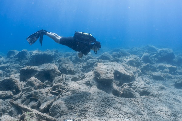
During the 2019 season, ten stone anchors were located in the deeper offshore waters. In the 2023 season, the area of the stone anchors was revisited as these findings required further investigation and better recording. Unfortunately, only five of the stone anchors were successfully relocated. They were more thoroughly photographed underwater and a record of their locations was taken using GPS. Two of them were lifted and transferred to the Local Archaeological Museum of Kourion in Episkopi.
Offshore survey beyond 10 m deep and up to a maximum of 20 m was planned to be conducted to identify new finds and better understand the offshore area and approaches to the bay. The plan was to use an underwater scooter in order to facilitate surveying larger areas further offshore. However, some technical issues prevented undertaking of the scooter survey. Instead, archaeologists conducted line surveys following a compass bearing and used GPS to track their dives, in order to locate any new findings or/and features underwater. The line surveys were mainly conducted to the west of the tile wreck; however, only some scattered fragments of ceramics were identified. All the diver tracks were documented in the ArcGIS.
Finally, further investigation and analysis of the ceramic concentration to the east of the breakwater was conducted. Selected findings were lifted only when they were useful chronological and typological indicators.
(EK/SCH)
Description of figures:
Figure 1: Topographical survey of the breakwater by using Total Station (Photo by Professor Simon James).
Figure 2: View of the tile wreck (Photo by Steven Lopez).
Figure 3: Photographing one of the stone anchors (Photo by Carmen Obied).
Figure 4: View of the line survey (Photo by Carmen Obied).
Relevant Press Releases
